(The Ngorongoro Conservation Area covers 8,292 square kilometers in northern Tanzania. It is one of the three divisions that comprise Ngorongoro District in Arusha Region.
 NCA was established in 1959 as a multiple land use area, designated to promote the conservation of natural resources, safeguard the interests of NCA indigenous residents and promote tourism. NCA is a unique protected area in the whole of Africa where conservation of natural resources in integrated with human development.
The main features of the NCA include the Ngorongoro Crater, The Serengeti Plains that support about 2.0 millions migratory wildlife
 species of the Serengeti Mara-ecosystem (TAWIRI, 2003) and the catchment forest; and the Northern Highland Forest Reserve (NHFR) known as ‘Entim Olturot’ in Maa language. Other important features found in the NCA are the archaeological and palaeontological site located at Oldupai Gorge and the early human foot-prints that were discovered at Alaitole in Ngarusi area. Because of these particular features and the harmonious co-existence between wildlife and people that has existed for many years, NCA was accorded the status of a World Heritage Site and listed as one of the International Biosphere Reserves by the UNESCO’s Man and Biosphere Reserve Programme.
This map shows the crater, which is where we toured. Our hotel was on the crater rim, located at about 8:00.

The main feature of the NCA is the Ngorongoro Crater, a large, unbroken, unflooded volcanic caldera. The Crater, which formed when a giant volcano exploded and collapsed on itself some two to three million years ago, is 610 m (2,000 ft) deep and its floor covers 260 km2 (100 sq mi).[5] Estimates of the height of the original volcano range from fifteen to nineteen thousand feet (4500 to 5800 metres) high.

The crater highlands on the side facing the easterly trade winds receives 800–1200 mm of rain a year and is covered largely in montane forest, while the less-steep west wall receives only 400–600 mm; this side is grassland and bushland dotted with Euphorbia bussei trees. The crater floor is mostly open grassland with two small wooded areas dominated by Acacia xanthophloea.
We entered the crater on the northwest corner and followed the one-way road that descended steeply.

The Maasai are allowed to water and graze their cattle in the Crater but they must exit daily. This herd of cows was just coming up over the rim.

The men were likely selling items to other safari tourists.

But we were happy just taking pictures.

I'm glad we took a few group shots!

And then we descended into the crater and met this group of donkeys coming up, loaded with water jugs.

Three young girls walked alongside.

This kind of volcanic rock was found all over.

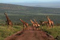
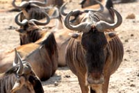
Aside from herds of zebra, gazelle, and wildebeest, the crater is home to the "big five" of rhinoceros, lion, leopard, elephant, and buffalo. The crater plays host to almost every individual species of wildlife in East Africa, with an estimated 25 000 animals within the crater. The current drought meant that we didn't see nearly those numbers of animals. Nearly half the wildebeests and zebras will leave during the migration too.

On my next post, I'll share some pictures of the wildlife we saw.
(Information from ngorongorocrater.com and wikipedia)


No comments:
Post a Comment